McWay Waterfall Trail – All You Need To Know Before Visiting
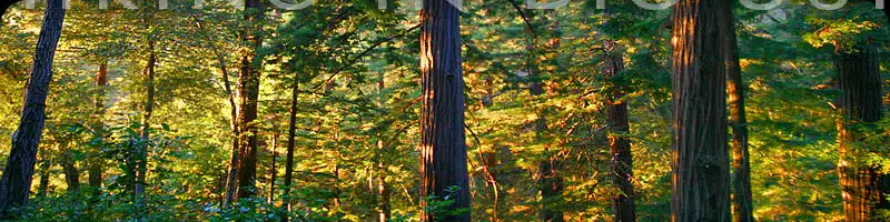
Even short trails can be worthwhile excursions, and the path to McWay Falls is one of the prime examples of must-do trips along Highway 1.
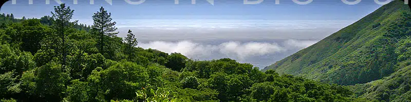
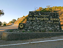
The trail is located in Julia Pfeiffer Burns State Park and provides both southern and northern coastal views, making it a unique and exciting trail to explore.
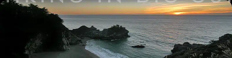
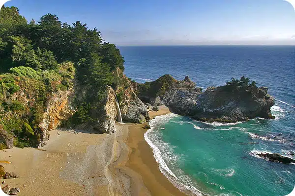
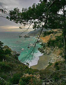
The majestic 80-foot McWay Waterfall, which cascades onto a pristine beach below, is arguably
the single most popular image of Big Sur.
It is also one of only eight waterfalls in the United
States that flow directly into the ocean.
Be sure to check out these beginner hiking tips before enjoying this amazing trail.
Hiking Facts:
• Length: .64 mile
• Type: Out & Back
• Difficulty: Easy
• Path: Flat, wide
• Elev. Gain: 50 feet
• Parking Fee: Yes
• Restrooms: Yes
McWay Falls Hike Trail Map
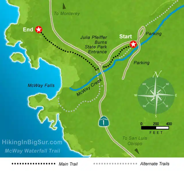
Use this map to help guide you on the trail to McWay Waterfall.
There are alternative routes to
the main route, including a narrow path that leads to the area above the falls instead of the
opposite cliffside.
While the view from here is not as spectacular, it is still a worthwhile excursion
if you have the time.
Book this full-day guided Big Sur hiking trip ⤵️
McWay Falls Hike
Park your car and head in a western direction, back towards Highway 1.
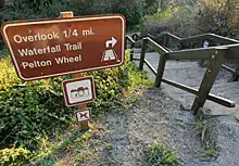
Keep an eye out for the “Waterfall Trail” sign to guide you, although finding the trail should be relatively straightforward.
If you parked in the overflow lot towards the south, walk back north in the direction of the lot
entrance, and the sign will be on your left.
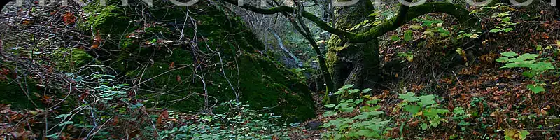
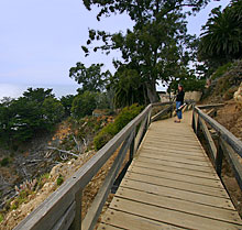
You’ll soon reach a flight of wooden stairs taking you down to a wide path that leads through a
tunnel under the highway.
This part of the hike is easy to manage and short, so it will take only a few minutes until you can see the ocean.
Turn right and follow the trail, which will now be mostly downhill until the falls appear to your left.
There are several vantage points along the path, typically with a photographer snapping
panoramic shots at each one.
If you’re visiting on the weekend during summer, these lookouts can become crowded, so make sure to be patient and factor in some additional time.
Until 1983, McWay Falls poured directly into the ocean since the beach as it is today did not
exist.
This narrow sandy stretch only came into existence due to a landslide and highway
construction which caused the bay to be expanded.
Historic photos of this former layout can still be viewed today and come as a stark contrast to the picturesque cove that is so well-loved by visitors to Big Sur.
Keep walking for another 100 feet or so until you reach the end of the path, which is marked by
another vantage point.
Here, you’ll see a wonderful view of the northern coast, and behind you
up the hill, the ruins of the old “Waterfall House” built by Lathrop and Helen Brown.
The gorgeous house was intended to be preserved as a museum but was instead torn down by the
state in 1965 after a fruitless struggle to save it. If you know where to look, you can still see
where the old tramway ran down from the highway to the house.
Considered a close pal of President Roosevelt, Lathrop Brown was not only a Congressman
from New York but also a generally influential person in the region in the 1930s.
He also constructed the iconic “Tin House” further north, which is an interesting place to visit during your time in Big Sur.
There is a nice bench under the trees here and plenty of photo opportunities.
According to Monterey County Place Names, “The point below the old ‘Waterfall House’ site has
a paralyzing-sheer 80-foot drop to the ocean.
A surveyor hired by Lathrop Brown called it ‘Poison Point’ because ‘one drop and you’re dead!'” This interesting anecdote, unfortunately, has some truth to it, so make sure to be careful when exploring the steep cliffs. Wearing sturdy shoes and staying away from the edge is highly recommended.
The McWay Falls, as well as the nearby creek, are named after Christopher McWay, a farmer
who settled in the area around 1874 with his son Christopher Junior.
The surrounding park receives its name from Julia Pfeiffer Burns, a famous pioneer and local resident who, together with her husband John B. Burns, ran a successful ranch in McWay Canyon.
This area is known for its rich history, and Big Sur has several museums collecting historic
artifacts and stories, including those of Julia Pfeiffer Burns and Christopher McWay.
In recent years, the Park Rangers have been cleaning out invasive non-native plants around the
waterfall house area and the McWay Waterfall trail, including mostly eucalyptus trees.
The ornamental plantings from several decades ago are largely left intact whenever possible.
The result is better views for visitors, along with a somewhat more native setting. Invasive plant
species pose a significant threat to local ecosystems in Big Sur, and the area around McWay
Falls is no exception.
Alternate Hiking in Big Sur close to McWay Falls
On your way back towards the tunnel under Highway 1 from the overlook, you can keep going
along the coastal path heading south.
This narrow path leads away from the main trail and,instead of taking hikers to the opposite end of McWay Falls, leads to the area right above them.
While the view is not comparable, this is still a worthwhile walk and makes for a more quiet
excursion with fewer others to share the trail with.
Another option for a quick and manageable hike close to McWay Falls is the walk to the Pelton
Wheel. Towards the right, you can spot the trail as you retrace your steps through the tunnel
close to the parking lot.
While this is by no means the most exciting hike in the area, it is a fun and short walk if you
have the time.
The wheel was once used to generate power for both local homes as well as a railway that connected the house to the mountains. Some of the remains of the tracks can still
be spotted if you look closely.
If you are in the area and going on a hike to McWay Falls anyway, you might want to take some
time to explore this landmark and its trail to make the most of your day in Big Sur.
How To Get To McWay Falls Trail
Julia Pfeiffer Burns State Park, which spans across 3,762 acres, is well marked and easy to
spot off Highway 1.
The entrance is located about 37 miles south of Carmel or 12 miles south of
Pfeiffer Big Sur State Park.
Note that the two parks have similar names but are 12 miles apart.
Take care when looking up directions so that you do not confuse the two. From the south, the
entrance is about 48 miles north of Ragged Point, which is 20 miles north of San Simeon.
If you park in the official parking area for 10$, signs will lead you west through a tunnel under the
highway out to the trail.
However you can also park for free outside the park along the west side of Highway 1.
If you do park here, you’ll want to head south along the highway to a gate in the fence and take the trail to the right. Keep heading north, and you’ll soon meet up with the regular trail at the tunnel.
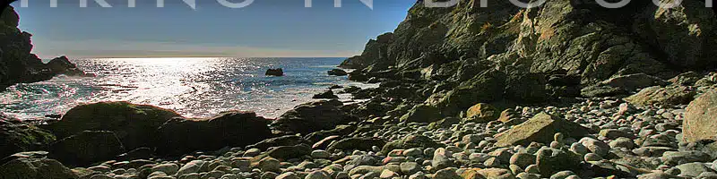
Unfortunately you can’t get to McWay Falls beach or ocean because going down there is illegal.
If you try you may get fined by rangers patrolling the area or get arrested. Stay on trails.
McWay Waterfall Trail Difficulty
The trail to McWay Waterfall can be considered more of a walk than a real hike.
It’s easy to manage for all experience levels, and the path is wide and level. It shouldn’t take much longer than 30 minutes, however, you might want to factor in some time to sit and enjoy the view of the
falls.
Also, consider that this trail is known to be very popular, and a lot of tourists driving Highway 1 will stop here for a brief time.
Avoid visiting on a weekend or public holiday if possible.
McWay Waterfall Hike Duration
You can complete the hike to McWay Falls in under 30 minutes if you’re in a rush.
However, this leaves little time to enjoy the breathtaking scenery and take photos along the way. An hour or even 45 minutes is a more realistic timeframe for this trail.
Consider that you’ll most likely be sharing the path with a good number of other visitors, and some of the lookout points may be crowded.
If you’re on a road trip and are just looking for a brief stop to see the falls before returning to your car, it’s best to visit in the early morning.
What to bring on a hike to McWay Waterfall
Since this is a very short hike, you won’t have to worry about bringing an excessive amount of
water with you. A small bottle will suffice, although you might want to leave an extra one in your
car on a hot day.
Even though most of the path to McWay Falls is broad and relatively flat, wearing sturdy shoes
is still recommended, especially if you’re planning on attempting to hike the additional trail to the
top of the waterfall. Since there are many steep drops and sharp rocks in this area, it’s easy to
trip and injure yourself. Always put your own safety first.
If you’re interested in bird watching, make sure to pack a pair of binoculars when going on a
hike along the McWay Falls trail. This area is known for its diversity, and many rare bird species
are native to the area.
Make sure to apply plenty of sunscreen as there is little shade on parts of the trail. It can get
extremely hot here during summer, so the best time of year to see McWay Falls is closer to September and
October. During these months, the weather will be pleasantly warm with little chance of rain but
not as scorching as July and August may be. The best time is during high tide, when the waterfall cascades straight into the ocean, offering an incredibly breathtaking view.
Remember that dogs are not permitted on this trail. Do not leave your pets in the car, even on a
cool day. Unfortunately, it’s the better choice not to bring them to the park at all.
Big Sur Hiking Trails Essentials
🚗 Do I need to rent a car for Big Sur?
Absolutely! I recommend renting through Discover Cars.
✈️ For best flight deals check Kiwi.com
💦 Stay Hydrated on the trails! I recommend this Brita water bottle.
🌞 Protect Yourself from the Sun ! Here’s my favorite SPF.
👟 Invest in a good pair of hiking shoes. Best for men and women.
🎁 Looking for a Gift for a Hiker in your Life? Here’s 40 Best Gifts For Hikers
🔎 Pack a pair of binoculars! Enhance your wildlife viewing experiences with a pair of binoculars.
📸 Capture Every Moment!
A camera strap is a must-have for hands-free convenience while hiking. Also, pack an extra memory card so you never run out of space for your stunning photos.
🏠 Where should I stay in Big Sur? Browse on Booking.com and VRBO. For a special experience, check out my guide on best glamping in Big Sur!
🚐 Interested in an RV experience? RVshare and Outdoorsy are fantastic platforms to find the perfect RV for your Big Sur adventure.
🎧 Download a self-driving audio tour of Big Sur here
Links To More Information
• Where this trail lies along the Big Sur coast
• Historical information on the area
• Description of a Pelton wheel
• California State Parks info page
• Aerial view of the area